Interview: Geospatial's Dave Fox on the latest imagery technology
Visit the Fujitsu Tech Hub at the Airmic conference in Harrogate to see the technology in action.
"Data" may have become somewhat of a hot topic in recent years, as businesses seek ways to both reap the rewards and manage the risks of the recent explosion in information. But for Dave Fox, CEO and founder of Geospatial Insight, the power of data is nothing new.
A geographer by background, Mr Fox has been in the business of data for thirty years, specialising in analysis of visual data - now a rapidly growing form of business intelligence. Geospatial Insight, which he co-founded in 2012, specialises in using satellite and drone imagery to create business and risk intelligence. In the words of Mr Fox, "data is our raw material".
During those thirty years, a lot has changed, especially the availability of data. "Take satellites. The data used to be scarce and expensive. Now it's plentiful - we have approximately 350 satellites available to us that can provide really useful data." Combined with improvements in artificial intelligence and cloud storage, this proved a powerful driver for creating a commercial case for image-based intelligence.
The pace of change has been breath taking, he says. Technologies and capabilities used to evolve over years, now it is just weeks and months. "We can do more now than we could even three months ago. The technology to harness and process data is changing so quickly."
Geospatial Insight will be exhibiting at Airmic's first ever Tech Hub at its conference in June - a cutting-edge exhibition sponsored by Fujitsu, Airmic's technology partner. The Tech Hub will showcase some of the latest cyber, AI and cloud technologies available to businesses and risk managers.
Visitors to the Tech Hub will have the chance meet industry experts, explore the latest business challenges in their field and see technology in action. On-site demos will include a flight simulator, a 360-degree security assessment, mobile and sensor based RFID solutions and the chance to speak to an intelligent chat-bot.
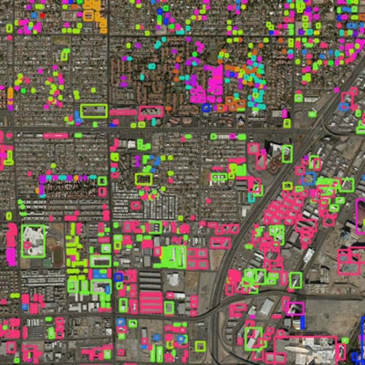
Geospatial will be revealing their latest product for assessing property risk. Delegates will have the chance to see how satellite imagery, with a resolution of 32cm, combined with publically available data, can be used to build an accurate risk profile of buildings around the world in just minutes.
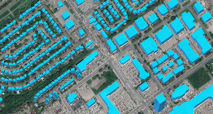
Satellite images © DigitalGlobe 2019
This data can be used by insurers, brokers and businesses to gain a far more accurate risk profile and support pricing strategies.
"The key is that we can do it at scale and at a reasonable price," says Mr Fox. Similar technology exists in the US, he says, but is either more costly or is driven by drone use which is far harder to scale up.
The product is currently in its final stages of production, says Mr Fox, so it really will be hot off the press at the Tech Hub.
Click here for more information about the Tech Hub, including a list of exhibitors.
Click here for more information about the Airmic Conference and to register.
Dave Fox is CEO and founder of Geospatial Insight