Flood risk: how satellite imagery can support response and recovery
The destruction of property and infrastructure from flood damage can cost hundreds of millions of pounds. The risk of flooding is predicted to increase as climate change creates more frequent and intense weather events. So, how should risk managers prepare for the future of flood risk? By Dave Fox, CEO, Geospatial Insight.
Quantifying flood in the UK
The UK is well overdue a major flood. No one can predict exactly when the country will suffer the next big deluge, and there is no way of knowing how costly and damaging it will be. This sentiment was echoed by Huw Evans, director general of the Association of British Insurers (ABI), who commented on the "potentially drastic consequences" if we fail to act on flood risk at the launch of the Environment Agency's long-term strategy in May 2019.
He continued: "A lack of major floods in recent years is no cause for complacency. As well as building defences, we need to increase awareness of flood risk and encourage home and business owners to put in place their own measures to protect their properties too."
Following a very soggy June in the UK, that same month, an analysis by Flood Re, a scheme set up by insurers and the government to cut the cost of property cover for people and businesses in flood-prone areas, showed that inland flooding would cost the entire country almost three times more on an annual basis without defences - £1.8bn rather than £700m.
These recent reports demonstrate how important it is that there is a relentless focus on the issue of flood to ensure consumers and businesses can continue to live and work uninterrupted.
Risk management and modelling
Risk mitigation and disaster response go hand-in-hand to reduce the impact of flooding, lowering the damage and cost of flooding and improving flood modelling. Flood exposure is persistently rising not just in the UK, but across the globe, which brings new challenges for the insurance and risk management industries. Taking note of the changes in society, such as the need to house an ever-growing population and build on green-field sites, there is a requirement to model and price flood risk effectively, while at the same time managing the increased frequency and severity of claims - all of which drive the cost of flooding higher.
But having highlighted the scale of the problem and acknowledged the challenges faced by the government and its industry partners, what else can be done to mitigate the risks of flooding in the UK?
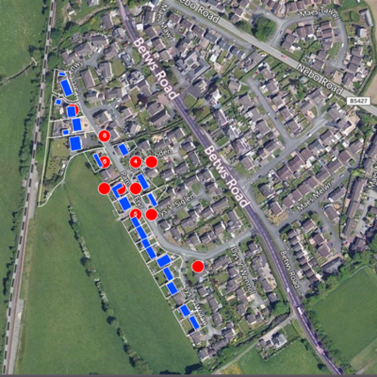
Let's take a recent example and see what the learnings were from the flooding in Wales when the River Conwy burst its banks and flooded parts of the town of Llanrwst, Conwy in March 2019.
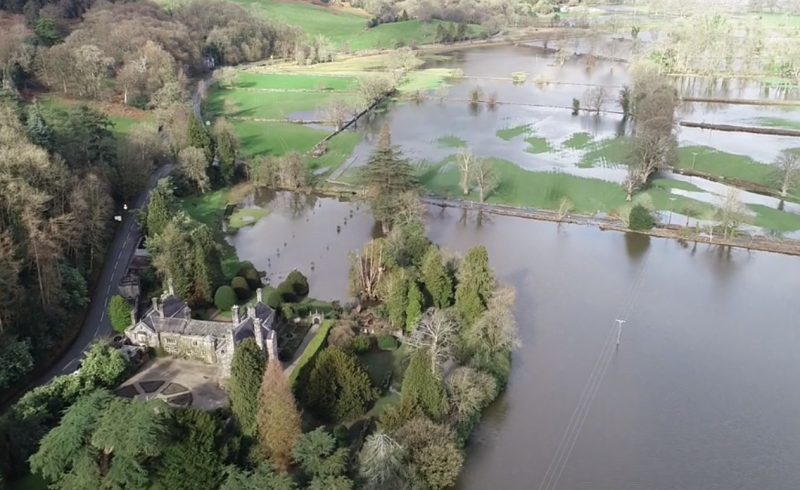
The River Conwy burst its banks and flooded parts of the town of Llanrwst, Conwy in March 2019
The image below shows results of some analysis of the flood area, including flood depth measurement and analysis at a property-by-property level. Other sources of data, such as social media posts, can be integrated into the analysis too. Social media scraping tools extract information relevant to a given flood event, for example pictures uploaded onto social media platforms of homes or businesses that include estimated depth and severity of the flood.
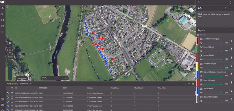
Oblique drone video images and screenshots from VIP, Geospatial Insight's online analytics platform
The key takeaway here is that in order to get people's homes and businesses back to normal as quickly as possible after a flood event, being able to assess the damage and respond quickly to pay claims and make repairs is essential. Having access to a service that captures imagery in real-time and gathers data immediately on the damage and severity as the flood unfolds and develops is imperative for making swift reparations to homes and businesses. Flood Re does exactly that using geospatial imagery and analysis to support its work, but businesses can use this service too.
As natural disasters increase in their frequency and severity, the efforts to recover from them will take longer and cost more. That's why businesses need to prepare now in order to mitigate the inevitable effects of flooding that can't be too far in the future.